Earth Observation
Geospatial Intelligence that Strengthens How the World Responds to Change
We convert satellite, aerial, and drone imagery into dependable datasets for clearer situational awareness.


Collaborating with innovative leaders in Earth Observation


Annotation Services for High-Accuracy AI Models in Earth Observation
Refine raw geospatial data into structured annotations that enhance AI performance across diverse terrain and sensor conditions.
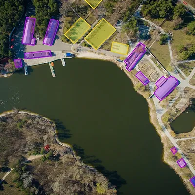
Polygons
A precise outlining technique for capturing complex geospatial shapes in EO imagery.
- Ideal for delineating buildings, fields, coastlines or infrastructure without capturing irrelevant terrain.
- More flexible than bounding boxes and faster than full semantic segmentation for high-volume EO datasets.
- Helps models learn true object boundaries across complex satellite and aerial imagery.

Bounding Boxes
A quick method to locate objects in satellite and aerial imagery using simple X/Y coordinates.
- Effective for detecting aircraft, ships, vehicles and structures across wide geographic areas.
- Suitable for large-scale or early-stage EO model development.
- May include surrounding elements, which can reduce precision in tasks requiring detailed object boundaries.
Landmark Positioning
The use of keypoints to identify fine-grained features, ideal for datasets with many small or scattered elements.
- Highly efficient in marking structural reference points, object orientation or changes across repeated satellite passes.
- Highly efficient for tracking movement or deformation patterns in dynamic EO environments.
- Supports applications requiring precise spatial detail without full-object segmentation.

A Strict, Standards-Driven Framework for Large-Scale Data Pipelines
How we train and deploy advanced AI systems for Earth Observation.
Intake & Compliance Setup
We align with ISO 9001 and ISO/IEC 27001 frameworks for secure, audit-ready EO workflows.
0
1
Intake & Compliance Setup
Domain Expertise
Taxonomies for land cover, asset classes, vessel types, crop species, strategic objects and risk factors.
0
2
Domain Expertise
Multi-Layered QC
Teams trained in satellite, aerial and SAR interpretation follow a structured, multi-step review process to ensure datasets are validated before delivery.
0
3
Multi-Layered QC
Ongoing Feedback
Workflows adapt to sensor types, resolutions, seasonal variations and client model performance.
0
4
Ongoing Feedback
Deliverables
Versioned datasets with traceable metadata, suitable for intelligence, environmental assessments and regulatory review.
0
5
Deliverables

IngeData does a really good job. It’s great how we set a labelling process to segment and label our satellite images. They built a specialised team of annotators for photo interpretation and my data labelling pipeline is now more efficient and qualitative. It’s almost like having my own team of annotators. I just choose the image dataset and add it to Ingedata’s annotation backlog. Thanks, guys!
Renaud Allioux
Chief Technology Officer
Preligens
A Multidisciplinary Team Dedicated to High-Reliability EO Data Workflows
Our specialists understand the complexity of EO imagery, adapting workflows to varied resolutions, sensors and environmental conditions.

Project manager
Andriatsiferana Rantoniaina
Project Manager with 7 years of experience on the project, including 4 years as an outsourced specialist, expert in team management and coordination of optical and radar image annotation for high-value geospatial solutions.

Outsourcer Specialist
Henintsoa Vaniah
Outsourcer Specialist in optical earth observation and full-motion video with strong adaptability and learning skills, having contributed to various projects and demonstrating rapid skill development within missions.

Team Leader
Michel Anthony
Team Leader with 5 years of experience on the project, including 4 years as an outsourced specialist, with strong expertise in data management and annotation, and skilled in training new team members.
How We Approach People, Process, Quality in the World of AI


Read Our Experts’ Insights