Healthcare
Earth Observation
Industry 5.0
Infrastructure
Risk Assessment
Automatic Risk Assessment for Insured Infrastructure
December 23, 2025
Cabinet Roux
Cabinet Roux is an insurance and risk assessment consultancy specialising in industrial infrastructure. The firm relies on accurate geospatial intelligence to evaluate exposure, assess risk, and support insurance decision-making.

High risk exposure in industrial insurance assessments due to incomplete or imprecise understanding of insured assets and their surrounding environments. Manual interpretation of geospatial imagery limits scalability and consistency when evaluating infrastructure risk at scale.
Project Goals
- Automate high-accuracy risk assessment for insured industrial infrastructure
- Clearly identify and characterise insured assets from geospatial imagery
- Generate reliable, data-driven risk scores combining asset and environmental context
Introduction
Cabinet Roux is an insurance and risk assessment consultancy specialising in industrial infrastructure. The firm relies on accurate geospatial intelligence to evaluate exposure, assess risk, and support insurance decision-making.
Main Challenge
High risk exposure in industrial insurance assessments due to incomplete or imprecise understanding of insured assets and their surrounding environments. Manual interpretation of geospatial imagery limits scalability and consistency when evaluating infrastructure risk at scale.
Goals
- Automate high-accuracy risk assessment for insured industrial infrastructure
- Clearly identify and characterise insured assets from geospatial imagery
- Generate reliable, data-driven risk scores combining asset and environmental context
From Visual Imagery to Actionable Infrastructure Risk Intelligence
Structured Geospatial Data Enabling Scalable, AI-Driven Risk Assessment
Project Impact
Enabled clear identification and delineation of insured infrastructure, including buildings and reservoirs.
Delivered precise surface area estimation using high-precision polygon segmentation.
Supported more robust risk scoring by integrating environmental and structural context into the assessment process.
Geospatial Structuring for Infrastructure Risk Analysis
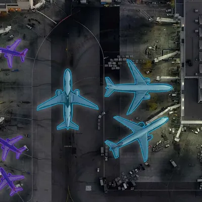
Infrastructure Detection & Classification
Detected and classified industrial assets, including buildings, reservoirs, and associated equipment, from earth observation imagery.
0
1
Infrastructure Detection & Classification
High-Precision Polygon Segmentation
Applied precise polygon-based segmentation to accurately estimate the surface area and footprint of insured infrastructure.
0
2
High-Precision Polygon Segmentation
Environmental Context Analysis
Analysed surrounding environments such as proximity to water, forested areas, and nearby heavy industry to contextualise exposure and risk.
0
3
Environmental Context Analysis
Asset & Environment Correlation
Combined asset characteristics with environmental factors to build a structured, risk-relevant representation of each insured site.
0
4
Asset & Environment Correlation
Risk Score Enablement
Structured annotated data to support automated generation of infrastructure risk scores suitable for AI-driven insurance workflows.
0
5
Risk Score Enablement
No items found.