Healthcare
Earth Observation
Industry 5.0
Agriculture
Precision Farming
High-Accuracy Automation for Large-Scale Weed Detection and Mapping
December 23, 2025
Telespazio
Telespazio develops advanced geospatial solutions, including AI-driven tools that support precision agriculture, crop monitoring, and large-scale environmental analysis.

The early and accurate identification of Datura stramonium—a highly toxic invasive plant—in vast crop fields where it can contaminate entire harvests if not precisely geolocated and removed.
Project Goals
- Detect and map datura infestations across agricultural plots using drone imagery
- Validate and refine pre-annotated datasets at scale
- Deliver consistent, high-quality data to support accurate weed identification and control

Introduction
Telespazio develops advanced geospatial solutions, including AI-driven tools that support precision agriculture, crop monitoring, and large-scale environmental analysis.
Main Challenge
The early and accurate identification of Datura stramonium—a highly toxic invasive plant—in vast crop fields where it can contaminate entire harvests if not precisely geolocated and removed.
Goals
- Detect and map datura infestations across agricultural plots using drone imagery
- Validate and refine pre-annotated datasets at scale
- Deliver consistent, high-quality data to support accurate weed identification and control
Scalable Weed Intelligence for Precision Agriculture
Eliminating Health Risks and Harvest Losses Through Targeted Geointelligence
Project Impact
270,000
Processed 270,000 agricultural images across two large-scale annotation campaigns.
Trained and deployed annotation teams in under one week to validate detection results.
Enabled accurate mapping of datura infestations to support improved weed control strategies.
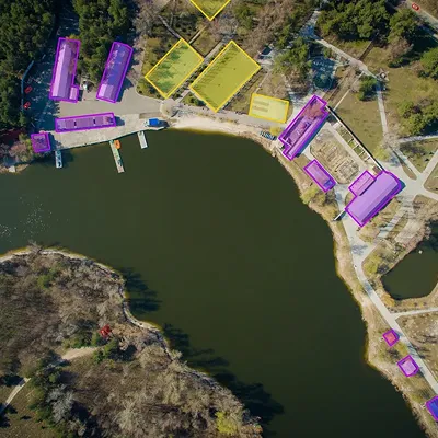
High-Resolution Invasive Species Identification
Precise Polygon Labeling for Early-Stage Weed
Applied precise polygon-based annotation to detect early-stage datura infestations, enabling timely intervention and better crop management.
0
1
Precise Polygon Labeling for Early-Stage Weed
Multi-Temporal Image Analysis (Early vs. Late Detection)
Analysed drone imagery across multiple time points to identify weed growth progression, supporting early detection and continuous monitoring.
0
2
Multi-Temporal Image Analysis (Early vs. Late Detection)
Geolocation Accuracy for Ground Intervention
Ensured accurate geospatial positioning of annotated infestations to guide precise ground-based weed control measures.
0
3
Geolocation Accuracy for Ground Intervention
Processing Tens of Thousands of Drone Images
Managed and validated over 270,000 high-resolution drone images across two large-scale campaigns, maintaining consistent annotation quality at scale.
0
4
Processing Tens of Thousands of Drone Images
Multi-Crop Adaptability
Developed workflows adaptable to different crop types and planting conditions, ensuring reliable weed detection across diverse agricultural settings.
0
5
Multi-Crop Adaptability
No items found.