Healthcare
Earth Observation
Industry 5.0
Defence
Computer Vision
Delivering 95% Accuracy in Aerospace & Defence Object Detection
December 23, 2025
Safran
Safran is a global aerospace and defence technology leader developing advanced AI-powered systems for surveillance, reconnaissance, and operational intelligence.

High operational risk in aerospace and defence applications due to insufficiently precise object detection in complex optical and SAR imagery. Ingedata addresses this by delivering pixel-level, high-accuracy annotations capable of supporting mission-critical AI performance requirements.
Project Goals
- Strengthen internal AI systems for aerospace and defence use cases
- Achieve highly accurate pixel-level object detection in SAR, satellite, and video data
- Enable production-scale annotation throughput without compromising quality
Introduction
Safran is a global aerospace and defence technology leader developing advanced AI-powered systems for surveillance, reconnaissance, and operational intelligence.
Main Challenge
High operational risk in aerospace and defence applications due to insufficiently precise object detection in complex optical and SAR imagery. Ingedata addresses this by delivering pixel-level, high-accuracy annotations capable of supporting mission-critical AI performance requirements.
Goals
- Strengthen internal AI systems for aerospace and defence use cases
- Achieve highly accurate pixel-level object detection in SAR, satellite, and video data
- Enable production-scale annotation throughput without compromising quality
Elevating Strategic Intelligence Through Expert Visual Recognition
Strengthening Aerospace and Defense Capabilities with Precision Annotations
Project Impact
99.81%
Exceptional Accuracy: Achieved 99.81% accuracy for 11.1 million observables in 2023.
95%
Technical Mastery: Successfully identified pixel-sized objects in SAR imagery with over 95% accuracy.
100
Operational Scalability: Scaled a team of nearly 100 people (photo analysts, project managers, and team leaders) starting from 2018.
Advanced Multi-Sensor Data Enrichment
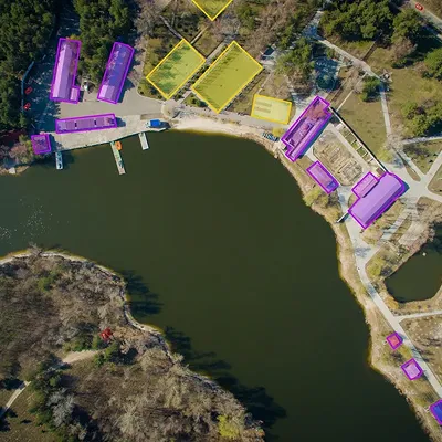
High-Precision Optical & Satellite Image Annotation
Delivered expert annotation across optical and satellite imagery with strict adherence to accuracy and consistency standards required for aerospace and defence applications.
0
1
High-Precision Optical & Satellite Image Annotation
SAR Geometry Expertise
Applied advanced geometry and domain expertise to accurately annotate SAR imagery, addressing signal noise, artefacts, and complex object boundaries unique to radar data.
0
2
SAR Geometry Expertise
Production-Scale Video Annotation
Executed high-throughput video annotation workflows, achieving 2,500 boxes per hour while maintaining alignment with real-time AI performance requirements.
0
3
Production-Scale Video Annotation
Multi-Level Classification & Labeling
Implemented precise, multi-level object classification frameworks aligned with Safran’s internal KPIs for accuracy, efficiency, and operational relevance.
0
4
Multi-Level Classification & Labeling
Scalable Workforce Deployment
Deployed a 93-person specialist annotation team operating within Safran’s platform and CVAT to support sustained, large-scale production.
0
5
Scalable Workforce Deployment
No items found.